Altitudes
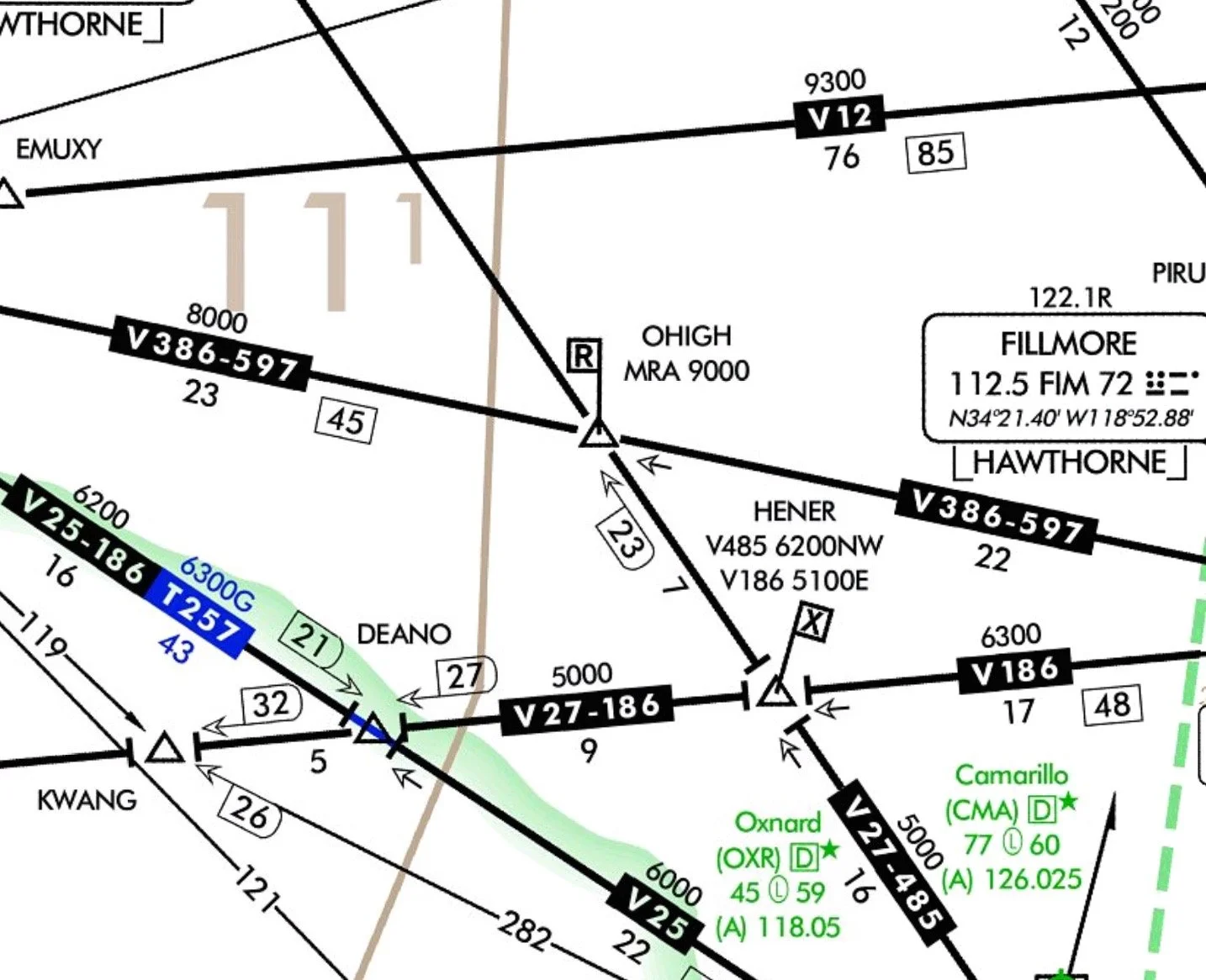
MEA (Minimum Enroute Altitude): the lowest published altitude between radio fixes that ensures acceptable navigational signal coverage and meets obstacle clearance requirements. Climb procedure when approaching a fix beyond which a higher MEA exists: A pilot may begin to climb to the new MEA at the fix.
MOCA (Minimum Obstruction Clearance Altitude): the lowest published altitude between radio fixes on VOR airways, off airway routes, or route segments that meets obstacle clearance requirements, and that ensures acceptable navigational signal coverage only within 25 statute (22 nautical) miles of a VOR.
MCA (Minimum Crossing Altitude): the lowest altitude at certain fixes at which aircraft must cross when proceeding in the direction of a higher MEA. Climb procedure when approaching a fix at which an MCA exists: A pilot should initiate a climb so the MCA is reached by the time the intersection is crossed. An MCA will be charted when a higher MEA route segment is approached. The MCA is usually indicated when you are approaching steeply rising terrain and obstacle clearance and/or signal reception is compromised.
MRA (Minimum Reception Altitude): the lowest altitude at which an intersection can be determined by means of navaids.
MAA (Maximum Authorized Altitude): the maximum usable altitude or flight level for an airspace structure or a route segment that ensures adequate reception of navigation aid signals.
MVA (Minimum Vectoring Altitude) is the lowest MSL altitude at which an IFR aircraft will be vectored by a radar controller, except as otherwise authorized for radar approaches, departures, and missed approaches. The altitude meets IFR obstacle clearance criteria. It may be lower than the published MEA along an airway or J-route segment. It may be used for radar vectoring only upon the controller's determination that an adequate radar return is being received from the aircraft being controlled. Charts depicting minimum vectoring altitudes are normally available only to the controllers and not to the pilots.
OROCA (Off-Route Obstruction Clearance Altitude): this provides obstruction clearance with a 1000-foot buffer in non-mountainous terrain areas and a 2000-foot buffer in designated mountainous areas within the United States. This altitude might not provide signal coverage from ground-based navigational aids, Air Traffic Control radar, or communications coverage.
If no applicable minimum altitude is prescribed (no MEA or MOCA), the following minimum altitudes apply for IFR operations:
Mountainous terrain—at least 2000 feet above the highest obstacle within a horizontal distance of 4 NM from the course to be flown.
Other than mountainous terrain—at least 1000 feet above the highest obstacle within a horizontal distance of 4 NM from the course to be flown.
IFR flights within controlled airspace (Class A, B, C, D, or E) shall maintain the altitude or flight level assigned by ATC. In uncontrolled airspace (Class G), altitude is selected based on the magnetic course flown: Below 18,000 feet MSL:
0 to179°—odd thousand MSL
180 to 359°—even thousand MSL
18,000 feet up to but not including 29,000 feet MSL:
0 to 179°—odd flight levels
180 to 359°—even flight levels
Cruise Clearance – ATC may assign a block of airspace to a pilot, from minimum IFR altitude up to and including the altitude specified in the cruise clearance. The pilot may level off at any intermediate altitude, and climb/descent may be made at the discretion of the pilot. However, once the pilot starts a descent, and reports leaving an altitude in the block, he may not return to that altitude without additional ATC clearance. Sometimes the cruise clearance will authorize you to execute an approach upon arrival at the destination airport. ATC will not issue further clearance for approach and landing. When you are operating in uncontrolled airspace on a cruise clearance, you are responsible for determining the minimum IFR altitude. In addition, descent and landing at an airport in uncontrolled airspace are governed by the applicable visual flight rules and/or operations specifications.
VFR-On-Top—A pilot on an IFR flight plan operating in VFR weather conditions may request a VFR-On-Top in lieu of an assigned altitude. For reasons such as turbulence, more favorable winds aloft, etc., the pilot has the flexibility to select an altitude or flight level of his or her choice (subject to any ATC restrictions). Pilots desiring to climb through a cloud, haze, smoke, or other meteorological formation and then either cancel their IFR plan or operate VFR-On-Top may request a climb to VFR-On-Top (which is still an IFR clearance). VFR-On-Top is prohibited in Class A airspace.
When operating VFR-On-Top, pilots must:
a. Fly at the appropriate VFR altitude
b. Comply with the VFR visibility and distance from cloud criteria
c. Comply with instrument flight rules that are applicable to this flight; i.e., minimum IFR altitudes, position reporting, radio
communications, course to be flown, adherence ATC clearance, etc.
Oxygen requirements:
a. At cabin pressure altitudes above 12,500 MSL up to and including 14,000 MSL, the minimum flight crew must use oxygen after 30 minutes.
b. Above 14,000 MSL up to and including 15,000 MSL, minimum flight crew must continuously use oxygen.
c. Above 15,000 MSL, each passenger must be provided with supplemental oxygen and the minimum flight crew must continuously use oxygen.

